Monday, February 13, 2012

"Crossed the deserts bare, man, I've breathed the mountain air, man" - Utah traverse!

Hi all,

Our revised itinerary took us from northernmost Utah almost due south to Arizona. The state of Utah is beautiful and so diverse in terms of the geology/geography. The Johnny Cash line in the title is a little misleading, as we encountered the mountains FIRST as we were driving south and ended in the desert.

Our first stop of interest the morning of our Utah traverse was the Great Salt Lake. Below is a satellite image of the lake, it's huge! The size makes it almost impossible to get a good view of it from the ground. The lake is the largest U.S. lake west of the Mississippi River. It is a remnant of Pleistocene-age Lake Bonneville, which was about ten times larger than the current size of the Great Salt Lake. At ~75 miles long and 25 miles wide, it's the 4th largest lake without an outlet in the world! It is only about 35 feet deep though, making it comparable in depth to the Chesapeake Bay. It is about 3-5 times saltier than the ocean and has no fish. Source: USGS Water Science Center.


One of the places recommended for viewing the lake was Ensign Park, a park in Salt Lake City, that is perched on top of a hill, ideally to get better viewing. What the website didn't say was that this park is a site of historical/religious significance for Mormons, so we were in the religious minority at the top. Oh, and did I mention this was the day of the rapture? So everyone else there had hymnals and were singing and praying and having picnics. We were just trying to get a view of the lake! This is me at the top of Ensign Peak with the lake in the background. Note how the water embays the ridges - the large Pleistocene lakes that formed in this area formed by rainfall filling up the low-lying areas (basins) between the high ridges (ranges) of the Basin and Range province that extends through most of the southwest and into Mexico. More on Basin and Range paleolakes in the posts about my trip to the Quinn River!


Salt Lake City seems like a nice place - it looked clean and not too built up. I've been told it's one of the prettiest airports in the U.S. to fly into, which I would believe considering the lake and snow-capped peaks all around! The picture below is from Ensign Peak, looking down on the Utah state capitol building.


After leaving Salt Lake City, we traveled a short distance south to visit the Bingham Canyon Copper Mine, the largest open-pit mine in the world! This is a picture taken from the interstate - the brown mounds are the sides of the mine - look how tall it is compared to the mountains!


This is a view down into the mine from the visitors' parking lot:


The visitors' center was really informative - there was a lot of historical stuff about the mine, a good display on how copper goes from copper ore to thick sheets of pure copper (the stuff that gets sold!), copper-bearing mineral samples, and displays of everyday, household objects that contain copper. There were also some pretty pieces of art made from copper and other metals. Megan and I both took a picture of this piece, so it must have been pretty good!


From the mine, we drove south toward Moab, and Arches National Park. As we drove, we saw some exposures of the Book Cliffs. These rocks are so named because they look like the side view of a book that has been opened and laid down on its cover. The layers of sedimentary rock include sandstones, shales, and coal beds, and represent the sediments of the Great Cretaceous Seaway that filled the interior of North America. The Cliffs are where Exxon geologists developed the practice of sequence stratigraphy in the 1980's. This is a picture we took from the road:


It's easy to see why people name rocks things like "ship rock" out west. I had never seen landscapes like this in person until this trip. The land is so flat, and some of the rocks are so isolated and stick up so abruptly from the surroundings, that they really do look like ships on a dry sea.


We arrived at Arches National Park around dinner time, only to find that all the campgrounds were full. We spent the majority of the evening and night driving around looking for a place to camp. Every single campground was filled up. We ended up unofficially sharing a family's campsite around midnight. We only infringed for about 5 hours before taking option c - sneaking out in the middle of the night! Just like at the Happiness Hotel (reference: Great Muppet Caper)!!!! That was probably our roughest night - most people didn't even pitch tents, they just slept in their sleeping bags on a tarp on the ground.

My real work is calling...unfortunately. Next post: Arches and Canyonlands!

Happy trails!
Sarah

Wednesday, February 8, 2012

Southbound

Hi all,

So we left off in northeast Wyoming at Devil's Tower, having made the decision to go south. We got a late start the next morning, as we were no longer on a set itinerary. The majority of the day we spent driving through Wyoming. We basically cut straight across from the northeast corner to the southwest corner. Below is the revised map of our trip:


Wyoming is an interesting state. It is divided up into isolated mountain ranges with large basins between them. What was surprising to me though was although it's not a desert, how brown and dry it looked in most places. There are a lot of natural resources though - there are lots of mining operations in Wyoming and you can see a lot of open pit mines and rigs from the interstate. Wyoming produces the majority of the coal in the US, which surprised me. We pulled over on the side of the road to check out this coal mine:


When coal seams catch on fire naturally - usually by lightening strike - the seam is burned to a red color and forms a resistant unit. This is referred to as "clinker." Because it is more resistant to weathering than the surrounding sedimentary rock, it forms the caps of mounds of rock. Wild coal fires in the Powder River basin of Wyoming were reported by Lewis and Clark during their expedition west.

It took most of the day to drive across the state. We ended the day at Fossil Butte National Monument, which was one of our stops in our original itinerary for the drive home. Fossil Butte is in the southwest corner of Wyoming, close to the borders of Utah and Idaho. We got to the visitors' center just a few minutes after it closed. The park ranger was heading to his car as we pulled up and upon seeing our vans, asked if we were from UT. When we said yes, we were from UT's geology department, he told us that he had been a master's student in our department years ago and reopened the visitors' center for us! Fossil Butte is known for the amazing fish fossils that come from there, but as I saw in the visitors' center, ALL the fossils - plants, fish, other animals - are equally amazing and beautiful!!! This site was a lake that had hosted many species of land and aquatic organisms. For some reason, which I believe is still unknown, the fish all died very suddenly, resulting in huge numbers of fossils in each layer of rock. Lakes are good places to preserve fossils are they are low energy environments and the rocks that form in them are fine-grained, so it is easy to see the fossils. Visitors to Fossil Butte can pay $40 to go out to the rock units and take home as many fossils as they want. Unfortunately, because we got there so late, we were not able to do so, but we did do a short hike up to the quarry where the scientists collect fossils. Here are some of my favorite fossils from the visitors' center:


This is me in front of the quarry rock layers. Note how thin and perfectly flat the layers are! This is characteristic of lake deposits. Also note how many layers I'm wearing! Dinner time in the Rockies is pretty cold!


We camped that night at Bear Lake, Utah. This was the view from our campground the following morning: so pretty! And look at the snow!


We hit the road in the morning after some tasty pancakes made by Cassaundra and Caycee:


A few miles down a pretty, windy, mountain road from our campground, we stopped to get a look at Bear Lake. Megan, me, and Felicia in the parking lot in front of the lake:


Northern Utah in a word was BREATHTAKING. The Rockies are "rockier" here than in the parts of Wyoming we saw and are all topped with snow. We drove by the Utah State campus and I almost got out of the car and transferred on the spot!! It's in such a beautiful location. I think most of our students were the most excited for southern Utah, which was also very cool, but northern Utah was amazing.

Got to go prep for my second lab section of the day! Next up: Utah traverse!

Happy trails,
Sarah

Thursday, January 26, 2012

Over the ground lies a mantle of white...

Hi all!

So on day 3 after visiting Crazy Horse, we headed to our campground and made dinner and set up our tents. It was raining on and off and pretty cold, but we had some tasty chili and Jackson somehow managed to build a fire, despite the wet conditions. The next morning it was pretty cold when I woke up, as I was getting out of the shower, Felicia was entering the bath house, shivering, and complaining about walking from her tent in the snow. Assuming she was over-exaggerating, I laughed, until I stepped out the door and saw this:


That white stuff on the ground and on our tents? Snow. And it only got worse as the day progressed!! Nevertheless, after packing our stuff up, we headed to Mount Rushmore to try to catch a glimpse of the presidents' faces, despite the fog, snow, and cold. We took the Needles scenic by-way that goes through the Black Hills area, and it was beautiful! A few things about the Black Hills: the Black Hills were formed during the uplift of the Rocky Mountains - they are actually billion-year-old metamorphic rocks that have been brought to the surface and broken through the overlying, younger, sedimentary rock units. The main granite in the Black Hills is the Harney Peak granite, which is what Mount Rushmore and Crazy Horse are carved in. The granite is very old, about 1.7 billion years old, but is younger than the metamorphic rocks of the Black Hills that it intrudes. The granite was brought to the surface as the Black Hills were being formed, about 50 million years ago. The "Needles" that are referred to in the area are the granite peaks that are resistant to weathering and stick up like needles from the rest of the landscape. Interestingly, the Turks give granite peaks the same name! "Sivri" means "needles" in Turkish and the town of "Sivrihisar" was named for the surrounding granite peaks in the mountains. The granite, at least from a distance, is very white, which seems to be in conflict with the "Black Hills." The Black Hills got their name from the dark dark green pine trees that are so abundant in the area and make the hills appear almost black from a distance. Unfortunately, the pine population in the area is suffering due to the recent arrival of a pine beetle of some sort. The trees that are still there though looked beautiful in the snow! This is a picture of what the Needles by-way looked like as we were driving back from Mount Rushmore. The "blackness" of the hills is very apparent here against the white snow!


Here is a picture of Mount Rushmore taken from just outside the Visitors' Center door. I think I was one of the few people to get a shot of it! The fog was very thick and after hanging out by the door for a while, I managed to snap this during a tiny break in the fog. Good things come to those who wait :)


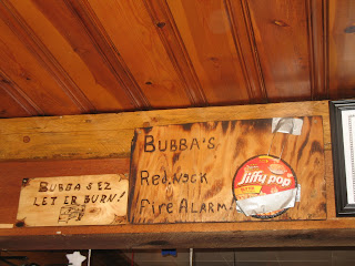
After braving the cold and snow to get a glimpse of Mount Rushmore, we took in some local culture at the "Sugar Shack" - home of the best burgers in the Black Hills! Megan and I were sitting at the counter though where we had a good view of the food prep station - the burgers were frozen. Oh well! Everyone enjoyed their lunch and the toasty diner nonetheless! They had a really high-tech fire alarm there, I felt like I had to get a picture. Maybe these devices will eventually make it to the rest of the country:


Thanks for the tasty grilled cheese, Bubba! I'll definitely be back :)

While the lunch at the Sugar Shack was good, this was also the place where mutiny and dissent began to grow. The majority of the trip participants, despite our warnings about average temperatures and weather conditions in the areas we would be traveling to, did not bring cold weather clothes or snow gear. In addition, we learned from the park rangers at Mount Rushmore that a huge snow storm was sitting over Yellowstone and was effectively not moving. Many of the roads into Yellowstone were closed due to the storm. Thus the idea of going south was born. However, we continued on our intended path that afternoon - ending the day at Devil's Tower National Monument in Wyoming.

There are several theories for how Devil's Tower was formed, however, all geologists recognize that it is an igneous intrusion of some variety that has undergone some degree of erosion, creating the tower shape seen today. It is made of a rock called "phonolite" which gets its name from the ringing sound the rock makes when struck with a metal object. It was not snowing at Devil's Tower, so we were able to do the ~1 mile hike around the base of the tower. This is me at the start of the trail.


You can see that the tower looks like a handful of pencils or rods of some sort. These are called columns. When magma cools underground, but in the shallow subsurface, it forms columns. These formations are often called "columnar basalts" and can be found around the world. A well known example is the Giant's Causeway in Ireland. The columns break over time due to physical weathering processes, littering the ground around the base with broken pieces of columns of various sizes and leaving the remnants stuck onto the tower.

From Devil's Tower we found our campsite but due to the inclement weather the night before, we opted to rent a few cabins the campground offered over using our tents. That night Megan and Kevin and I looked up weather reports and maps and made the decision to abandon the northern route and adopt a southern route instead. Our mutinous crew was very excited by the change of events and many students partook in revelry that lasted very late into the night.

Seminar time! More later on how our adventure progressed into uncharted territory!

Happy trails!
Sarah

Wednesday, January 25, 2012

Geoclub trip - The Geology of South Dakota, abridged.

Hi all!

Today I'm going to write about the geology we saw in our few days in South Dakota. As I think I said in one of my last two posts, there's so much to see in this area, it was impossible for us to see all the great stuff that's there, or even see everything at the places we did stop. This was a constant frustration for students throughout the trip who wanted to see everything at every stop. I tried to see it as a whirlwind tour, so that I would know where I wanted to return to in the future and how much time I would need to do it justice!

On day 2 of the trip we arrived at Badlands National Park in the mid-afternoon. The Badlands were so named because when French fur traders were traversing the northern part of the US, the rugged topography and barren landscape were "bad lands to cross." We now refer to "badlands" in the general sense as any sort of rugged landforms featuring sharp ridges. Typically, badlands are formed in relatively soft,sedimentary rocks (ex. mudstones) due to erosion by rainfall and runoff. The picture below is characteristic of the South Dakota Badlands. Today with park roads winding through it, it is not difficult to cross, but you can imagine that the first settlers to cross through this territory may have found it intimidating!


The Badlands are composed of many many layers of soft sedimentary rock, but the layers can be grouped into three sections based on rock type and erosional characteristics. In geology the technical term for this is "lumping." Students are often encouraged to "be a lumper not a splitter!" because it makes large-scale geologic interpretation more manageable. So if we "lump" the rocks, we see three groups with easily distinguishable characteristics. The lowest "lump" is composed of weathered shale, a fine-grained, mud-rich, rock. The shale weathers to a variety of colors, including gray, white, red, and yellow. Because shale is so soft, when it erodes, it forms rounded mounds. This is me giving some sort of lesson about horizontal layering of sediments, with the brightly-colored shale mounds in the background.


The clay in the shale forms a cool texture on the surface when it absorbs water and expands then contracts. The texture is called "popcorn texture." Yet another highly technical geology term :) Here is a close-up of the clay "popcorn" in the lowest lump.


The middle lump is also composed of a lot of mud and clay, but rather than being weathered shale, these are sediments that were carried east from the rising Rocky Mountains several tens of millions of years ago. The middle lump features thin, almost perfectly horizontal layers, in pastel colors. The rocks do not form mounds as they erode, but the rainfall does create sharp gullies that carve the slopes of the rocks and cuts across the layers. Some layers are more resistant than others due to a larger grain size or natural cements. These layers stand out against the more mud- and clay-rich layers. The middle lump is the thickest section of the Badlands and is what you see in most pictures:


Note how sharp and narrow the ridges are! Alan Howard says "you can't drink too many beers and walk on those things!" So true. The uppermost lump is fairly unique in the set. It is the thinnest lump by far and is composed of some layers of the mudstone, but has several layers of volcanic ash as well. The ash layers are bright white and more resistant to weathering than the mud, making the uppermost lump the most rugged. The bright white horizontal layers near the tops of the rocks in this picture are the ash layers. The ash was carried by wind from the volcanoes on the west coast of the U.S.


The Badlands have preserved a great collection of fossils from roughly the Eocene epoch, about 50 millions year ago. These fossils are about the same age as the fossils at the Gray Fossil Site near Gray, Tennessee. Similar animals are found at both locations, primarily mammals. The prehistoric creature that Nicole found most interesting at the Badlands Visitors' Center was the "pig dog." Pig dog is an actual animal from that time period, and fairly ferocious, at least based on the appearance of the fossilized form!

We camped in the Badlands that night - this was our campsite, how beautiful!!!!


The next day (only day 3!) we woke up early and drove further west to the Rapid City/Black Hills area of South Dakota. Kevin made us AWESOME burritos for breakfast on the campstove with eggs, cheese, onions, green peppers, and salsa. Yum!!

Our first stop of the day was at the SDSM&T geology museum on campus. Having been a SDSM&T student for a few weeks the summer before, I was excited to see the campus for the first time! It's very small, but their geology museum is really great! It takes up the whole floor of a pretty large building and has tons of fossils and great mineral, rock, and meteorite samples. I wish we could have a collection even half as big at McClung!! We spent about 1.5 hours looking around. We had some very intellectually inclined students on this trip, they made us so proud everywhere we went! :)


From the SDSM&T geology museum we headed over to the town of Hot Springs to the Mammoth Site. The Mammoth Site has the best collection of preserved mammoths anywhere in the world! The museum there is really cool, as it is also an active dig site that is staffed by seasons of volunteers. Anyone can volunteer to participate in the dig, you just need to go to an orientation! The museum was built on top of/around the dig site, so the dig is completely enclosed in a building that houses paleontology labs and the museum. The reason there are so many mammoth fossils here is because there used to be a watering hole at the location of the dig site during the Pleistocene epoch. However, the sides of the watering hole were steep, and the rock was shale (lots of mud, remember!), so the banks of the watering hole were steep and slick. Animals would try to get down to the water's edge but would not be able to climb back out, so they would drown. Over time, the lake filled in with mud and other sediments, forming a giant mammoth tomb. This is the location of the current museum. Below is a picture of a volunteer doing some excavation around a mammoth skull.


The last stop of day 3 was at Crazy Horse National Monument. It was too foggy to see the actual carving of his face, which was too bad, but we did watch the video of how the carving was started, and where they are now in terms of progress. Answer: not very far. When the sculpture is finished it will be the largest stone carving in the world, however, only a very small amount has been completed, as it is funded entirely by donations. There are two nice museums there, however, one with lots of Native American history and one about the designing and beginnings of carving the monument. Crazy Horse is carved from the same stone as Mount Rushmore: the Harney Peak granite. They save the smaller pieces when they blast and give them away to visitors. I'm not sure how many visitors want to take home a chunk of granite, but all of us swarmed the big crate of rocks and were very competitive about what pieces we dug out! It was pretty cold that evening and starting to drizzle, so the free coffee was also definitely welcome! The weather that evening should have tipped us off...continue to the next post (once I write it) to see why!

Got to go do a lab report!

Happy trails!
Sarah

Saturday, January 21, 2012

Geoclub trip Day 2 - A trip to Jurassic Park

Hi all!

Sorry for the false advertisement in my last post that I would have the Day 2 post finished last night - I had more schoolwork than I originally envisioned.

Anyway! So Geoclub trip day 2 - I left off in my narrative with Felicia's underwear being found in the road as we left our campsite that morning. After a quick breakfast at Mickey D's we hit the road and headed for our first stops of geologic interest in South Dakota. Again, let me start out this blog post with a huge endorsement - I went to field camp in Turkey (see previous posts) but the program was through South Dakota School of Mines & Technology. SDSM&T, located in Rapid City, SD, also runs a field program in the Black Hills. When I was applying to the Turkey program, I remember seeing the Black Hills option on the website as well and thinking "who would want to do that? lame." Judgmental, yes. BUT what I can now honestly say, as a previous skeptic, is that the Black Hills area of South Dakota is AMAZING!!!!!! The Hills themselves are pretty small but the area is beautiful and there's so much interesting stuff there in terms of geology, history, and cheesy tourist stuff (more on that later!) that Megan and I both felt like we could have spent several more days there.

Our first stop in South Dakota was in the town of Chamberlain, which is located on the Missouri River ("Big Muddy!"). We stopped there for a picnic lunch and showed the students the river terraces along the present channel. River terraces are abandoned floodplains that were active when the river was higher than its present level. That doesn't mean the river was actually deeper and filled the channel up to the height of the terraces, it means that the river hadn't cut through the material beneath yet. As the river erodes and cuts down more and more, it creates a deeper and deeper valley with several generations of terraces. A lot of field camps that go west stop at this location to see the terraces, so maybe our students will be seeing this spot again! Here is a picture of Kevin teaching the group about terrace formation and the type of rock seen in the background:


Megan and I spent a lot of time in the car reading aloud to each other from the "Roadside Geology" series. There is a book for every state (I think?!) and we had them for all the states we visited!! We got pretty into even the details of what we were seeing on the trip. For instance, we were nerdily able to immediately identify the rock type of the rip-rap along the river bank as being Sioux quartzite! It is a metamorphosed sandstone stained by oxidized iron-rich grains in the sand, so it has an overall pink appearance. Me being a nerd with my book (note the quartzite!):


I noticed that South Dakotans are pretty into three things: 1) dinosaurs, 2) large fake rodents, 3) advertising. One of the South Dakota gas companies has green dinosaurs at all its stations, so we saw lots of those guys, but we also saw lots of dinosaurs just hanging out in fields on the side of the road. Felicia and me on the gas station dinosaur:


Random local dinosaur grazing in the field along the interstate:


South Dakotans also like really large chipmunks apparently. This is the world's largest chipmunk, weighing 6 tons!


South Dakotans also really like advertising. For just about anything. You wouldn't believe how many signs there were for that chipmunk alone! There are many, but probably the biggest tourist trap in South Dakota is Wall Drug. What started out as a tiny drug store in Wall, SD, in the 1930's has grown into a sprawling tourist trap, complete with, as one might expect, a large dinosaur. It's basically the South-of-the-Border of the North. We saw signs for Wall Drug starting about 2 hours away from it. I think I counted about 90 signs total... We ate dinner at the Mexican restaurant there on night 2. This is the big sign out front when you pull up:


When in South Dakota though, make sure not to miss other great tourist attractions like 1880 Town (also has a dinosaur close by), the Corn Palace, and Deadwood!

I think I'm running out of usable space in this post (too many dinos and big chipmunk pictures!) so I'll have to make the next post about the geology of what we saw in the Rapid City area. We spent several days in the area, so consider this post all the "cultural" stuff from South Dakota and the next will be about the actual geology.

As some of you might know, at the time of writing, I am on a 13 days on $13 regimen. I am finding that when you can't spend money, you have much more time to do things you otherwise wouldn't do like read books and blog :) It's kind of nice! So be expecting regular postings over the next week+.

Happy trails!
Sarah

Friday, January 20, 2012

Geoclub trip...finally! - In the beginning there was a van...

Hi all!

So I'm finally starting to write about the Geoclub trip I took in May. I think it took this long just to process all the cool things I saw on the trip!

One of my favorite books, The Phantom Tollbooth, has a review on the back cover that starts with "Let me start by saying, this is the best book ever." Since the first time I read that book I have been impressed that someone publicly gave a book such an outstanding endorsement. The best book ever?!?! Wow! Well let me start my recollections of this trip by saying, after months of ruminating on the events of those two weeks, that this was the best trip ever. Hats off to Megan for her wonderful planning and improvising along the way!

Our first day we left the geology building at 6 am with our destination for the day being Lewis and Clark State Park, Iowa. We had several misadventures that day, beginning a mere three hours later at 9 am when we stopped in Kentucky for gas and gas station fare for those who hadn't brought breakfast. Everyone spills out of the big van, with Megan and myself being the last ones out. My "job" is to run over to the gas station to see if they take our Fleet 1 card that we had to use for the university vans. Upon returning, Megan whispers to me, "Sarah, I think I locked the keys in the van." Her suspicions were confirmed immediately by peering in through the van window. Yep, right there in the cupholder, the only set of van keys. As everyone hunkered down in the town's Chamber of Commerce building to stay out of the windy, unseasonably cold weather, we managed to call a local locksmith who was able to retrieve the keys for us. So with a slight delay, back on the road again!

This was taken when passing through Nashville, Illinois, if I remember right. It wasn't Nashville, TN, which was why we took the picture.


Strangely enough, we had a huge number of St. Louis fans in the car. Not sure what the hype is all about, but we did take this picture while driving by on the interstate.


There's not much geology above the ground driving through the Midwest. A lot of the geology of Indiana and surrounding locations is below the ground as caves. So not too much to see the first day aside from water towers and arches. However, we did encounter some "excitement" in Cameron, Missouri. In an attempt to catch up with the minivan, which had gained a considerable lead after our key excitement in Kentucky, we got a speeding ticket. However, not only did we get a speeding ticket, but all of us were asked to get out of the van and line up along the side of the road while the vehicle was drug-searched. All the dog found was my cinnamon-brown sugar mini-bagels. The process was long and drawn out, but at the end of the day we did find out, thanks to Megan, that the little camera in the cop car is not what they use to film "Cops." We were also informed by the cops that there are ticks in Missouri. Who knew?

The one piece of geology we did see that day were large loess deposits. Loess is very fine-grained sediment carried by wind that often forms steeply dipping mounds in previously glaciated terrain, hence the large loess mounds in the Midwest. Pictured below are the mounds we were able to see from the road.


We skirted Kansas City, so I didn't see it with my own eyes, but I'm sure it's plenty up-to-date! I have it on good authority from the minivan, which after the speeding ticket/drug bust had even MORE of a lead, that Omaha is pretty nice as well. Yet another place I didn't see with my own eyes.

We arrived at the state park very late that night and went straight to bed so we could get a fresh start in the morning. The morning started out quite exciting - as we were pulling out from our campsite someone spotted something magenta on the ground in the path of the van - it was Felicia's underwear. Great start to the trip: locking the keys in the car, speeding ticket, drug search, underwear in the road. Like I said, this was the best trip ever.

Got to go do real work, but I'll post Day 2 later tonight!

Happy trails!
Sarah

Friday, May 13, 2011

Trip West!

Hello all blog followers!

Monday morning at 6 AM I, along with 12 other UT geology students of varying age and grade level, are embarking on a 2-week road trip out west. We will be hitting the big national parks, monuments, and forests on the way: Badlands, Black Hills, Mt. Rushmore, Crazy Horse National Memorial, Tetons, Devil's Tower, Yellowstone, Bighorn Mtns, Glacier, Craters of the Moon, and the Green River Fossil site. And plenty of roadside geology in between! Below is a screen shot of Google maps showing our basic route.


I'll be off the grid while on the road, but I will take pictures and journal so there will be some nice blog posts when I get back!

Happy Trails!
Sarah